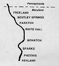
New Signs Bring History to Life on the NCR Trail
Texts from the eight interpretive signs include the following:
ASHLAND . . .
With the beginning of the Baltimore and Susquehanna Railroad in 1828, industry boomed along the Gunpowder River. In 1844, the Ashland Iron Works commenced operations with the building of its first furnace about 16 miles north of Baltimore City. Ashland was named for the Kentucky estate of Henry Clay, a prominent statesman of the period. A second furnace was completed in 1847. The iron works prospered during this time and throughout the Civil War period. The advent of railroads contributed to the boom days of iron manufacturing. Originally the Ashland Iron Works produced about 10 tons of pig iron per day. By 1864, with the completion of a third, larger furnace capable of producing 50 tons per day itself, Ashland had become one of the top producers of pig iron in the country.
At the height of its operation, the Ashland Iron Works employed more than 200 workers. Many of them had emigrated from Ireland, Germany and Italy to escape from famine and military service. The men worked 12 hour shifts for $1.00-$1.50 per day. The furnaces ran 24 hours per day. Company officials owned the town and rented houses to their employees for $1.50-$2.50 per month.
The company also built a one-room school house and a Presbyterian church for the use of the workers. $1.00 per month per child was deducted from the worker's salaries to pay for their children's education.
The development of the Bessemer steel process in 1866 spelled the end of pig iron and the Ashland Iron Works closed for good in 1884.
Renovated 1860 era buildings that can still be seen on Ashland Road include the general store, post office, iron works office, stone row and schoolhouse.
PHOENIX . . .
Phoenix, one of the many mill towns of the 1800s in Baltimore County, survives today as a secluded little village beside the Gunpowder River and the Northern Central Railroad 15 miles north of Baltimore. Today's Phoenix, with its big Victorian houses with their characteristic gingerbread trim, developed in the 1890s as a suburb of Phoenix Mill and its company located a half mile to its north.
The first industry at what eventually became Phoenix was a gristmill started in 1793 by Elijah Merryman and known as "Gunpowder Mills." A saw mill and a woolen mill soon followed. In 1847, Baltimore mill owner Thomas H. Fulton founded the Phoenix Cotton Mill. When he died shortly after in 1851, the property was sold at public auction. The auction notice listed a "factory house" 100 by 36 feet with an iron water wheel, a stone dam with 9 feet of waterfall, plus a town with 21 brick and log houses, a store, and a 2-story house. The property sold for $28,550. For the next few years the mill had a variety of owners. In 1875 the property was obtained by the Garrett family, noted Baltimore investment bankers. With improvements including a 54 inch turbine wheel and a 175 HP reserve steam engine, the mill was placed back in production in 1881. At this time the mill town had grown to 68 dwellings, the worker force numbered over 200, and 6,000 spindles were being used to manufacture twill and sheeting goods.
In 1903, the U.S. Cotton Duck Corporation, which now owned the mill, ceased its operations at Phoenix to take advantage of lower manufacturing costs in Alabama. By 1911, the town was nearly deserted as the area was expected to be flooded by the expansion of the Loch Raven Reservoir project. The final design of the Loch Raven high dam brought the back waters of the reservoir to the very walls of the mill. In 1922, Baltimore City obtained Phoenix, along with Warren Mill further downstream for $1,000,000. Warren Mills was drowned by the reservoir expansion and Phoenix, with its 4-story mill of Beaver Dam marble, was demolished.
Today only a roadside pond, the remains of a millrace, some fragments of a rail spur, and a few stone foundations mark the location of the once prosperous cotton duck industry that created the original village of Phoenix.
SPARKS . . .
In 1835, the Baltimore and Susquehanna Railroad constructed a track through Baltimore County which included a siding and switch near a large tract of land owned by the Sparks family. Railroad officials gave the name Sparks to the switch and soon area residents began to refer to the location as "Sparks' Switch." For some years a creamery, which can still be seen, was operated for farmers who brought their milk in daily to be separated. The cream was shipped to Baltimore while the skim milk was used by the farmers on their farms. With the passage of time, Sparks' Switch came to be known simply as "Sparks." In 1888, the area had grown to a point where "a substantial foot bridge 6 feet in width" had to be built across the Gunpowder. A combination passenger and freight station was operated by the Northern Central Railroad in 1889 to serve the community, appropriately named Sparks Station.
An interesting bit of history shows that the area along York Road today that we know as Sparks was once the town of Philopolis. Sparks was merely a cluster of homes and farms one mile to the east along the NCR tracks. Philopolis was the site of the Milton Academy, a well known private day and boarding school for boys. Also located there were a blacksmith and wheelwright shop, an undertaker, a milliner, and a general store. In time, the entire area came to be known as Sparks, and the village of Philopolis disappeared from county maps.
In 1909, six small rural schools were consolidated into what we know today as Sparks Elementary school (destroyed by fire in 1995). Initially the school was called Agricultural High School - many of its students rode the NCR's Parkton local to get to school. In 1913 a general store and warehouse was built and the post office was moved from York Road to Sparks. Sparks State Bank was built in 1916 next to the store along the NCR tracks. Interestingly, both the bank and the post office have been moved back to York Road which is now the main area of local business. The bank moved in 1954 due to a decrease in train activity as well as repeated flooding from the Gunpowder River - some of its safe deposit boxes were said to have contained water from past floods. The original Sparks Bank building is now operated as a Nature Center for young children by volunteers of Gunpowder Falls State Park in conjunction with the NCR Hike and Bike Trail which follows the old railroad path through northern Baltimore County.
MONKTON . . .
In colonial Baltimore County, trade and civilization followed the river valleys. Travel was easier through the bottom lands and the rivers powered paper, grist, and saw mills. The Gunpowder River valley was just one of the early avenues pointing north from the Chesapeake to York, PA. The Northern Central Railroad began in 1828 as the Baltimore and Susquehanna Railroad. Monkton, however, began as a small village nearly a century earlier and was called Charlotte Town at the time. Charlotte Town was part of Thomas Brerewood's 10,000 acre "My Lady's Manor." Brerewood had received My Lady's Manor from his daughter-in law Charlotte. Charlotte Town flourished as the dominant town of My Lady's Manor between 1740-1770. Robert Cummins, a wealthy miller in the Revolutionary War era, renamed the town after a place in Nova Scotia where he had settled in 1763 which was called Monckton. The "c" in Monckton was later dropped by area residents.
Several stone structures located in the area date from the mid to late 1700's and were built of stone quarried from north of Monkton station. The brick structures you see today were built during the mid to late 1800's. Historic buildings include the 1873 2-room schoolhouse just east along Monkton Road (most recently used as a Baptist Church), the 1858 hotel/general store, a town hall building, the station master's house, and the 1898 train station. An earlier, smaller station had been built in 1840.
With the advent of the automobile, more people began to move into the big cities. Trucks began to move much of the goods formerly traveling by rail. With these changes of the early and mid 1900's, Monkton and the railroad began a gradual slide into decline. In 1980, the Department of Natural Resources acquired the abandoned Northern Central Railroad right of way to be turned into a recreational pathway. The restored Monkton Station now serves as a visitor center for the Northern Central Railroad Trail or the "Hike-Bike Trail" as it is known to the area residents.
WHITE HALL . . .
After passing through the village of Monkton, the Northern Central Railroad continues northward through the abandoned villages of Pleasant Valley and Bluemount toward White Hall, a distance of approximately 3.5 miles.
Early in the 1800s, a large white house was built on a rise to the west of the Baltimore and Susquehanna Railroad (later to become the NCR) tracks. The community of White Hall today is said to have been named for this house. The house, which burned many years ago, was alternately used as a post office, train station, livery stable, and boarding house. White Hall once bustled as a commercial center in the midst of a farming community. There were 3 stores, a feed mill, a bank, a hotel, a grist mill, and a paper mill. At one time the paper mill operated 24 hours a day. The mill closed in 1984, but the building remains in use today by a local contractor.
The feed mill was an impressive 5-story wooden structure on Wiseburg Road which served as the community's landmark for 71 years until it was set on fire by an arsonist and burned in 1974. This property is now used as a maintenance shop for the Department of Natural Resources' NCR Trail. The 1909 White Hall National Bank served the community's banking needs until it was bought out in 1958. Today the old bank building serves as a residence for one of the park rangers. The old 16 room White Hall Hotel is now a private residence and can be seen just east of the NCR Trail along White Hall Road. Several beautiful late 1800s homes are scattered throughout the area featuring a variety of different styles of architecture.
The old grist mill is gone, but the mill pond can be seen behind the present post office. Of the 3 stores, one is closed but standing, one is an apartment house, and one is long gone. During the 1910-1925 time span, an agricultural fair was held, sponsored by the White Hall Farmers' Club. The White Hall Fairground is now nothing more than an overgrown hilltop field barely accessible by a deeply rutted unpaved road.
Like many other north Baltimore County towns and villages, White Hall's success was directly related to the success of the Northern Central Railroad. As railway business began to decline, White Hall began to revert to its origin as a quiet, peaceful rural village. White Hall today comprises a strip less than a mile of length along the Little Gunpowder [sic] Falls from Graystone Road to where Wiseburg Road ends at the old paper mill.
PARKTON . . .
At some point in the mid 1700s, a farmer by the name of Parke laid off a portion of his farm into building lots. Thus the village of Parkton came into being. Two notable events helped Parkton become a major commerce center between Baltimore and Pennsylvania - the completion of the York-Town Turnpike in 1810, and the extension of the Baltimore and Susquehanna Railroad in 1838. The Baltimore and Susquehanna would become the Northern Central Railroad in 1854. These two events paved the way for Parkton to develop into a major shipping point for farmers' milk, grain, and wood products.
Parkton grew into a village of some distinction. In the 1875-1910 era, the village could boast of a hotel, blacksmith shop, several churches, bank, schoolhouse, department store, grocery store, livery, undertaker, large warehouse, and a fine 2 story railroad station. The once grand 1860 era hotel and the 1910 era bank buildings may still be seen today. With the advent of the automobile, the demise of the railroad, the construction of I-83, and the devastating effect of several major storms in the 1970s, most notably hurricane Agnes in 1972, Parkton began to revert to its simpler beginnings.
The Parkton Local, also known as the "Ruxton Rocket," was more than just a train to those who depended on it for their daily commute into Baltimore. It represented a simpler time, a way of life not found anymore. The one-hour ten minute trip from Parkton passed through many quaint Baltimore County villages including White Hall, Monkton, Sparks, Ashland, Cockeysville, Ruxton, and Lake Roland; eventually arriving 28 miles later at Calvert Station in downtown Baltimore. Service on the commuter line was provided by a Pennsylvania Railroad 66 passenger-baggage, diesel electric motor car combine. The final run of this popular commuter coach was on June 27, 1959.
BENTLEY SPRINGS . . .
To look at Bentley Springs today it is difficult to imagine its past as a major destination from Baltimore along the Northern Central Railroad. This small village in upper Baltimore County is located just 4 miles below the Mason Dixon line and 31 miles north of Baltimore City. The hillsides around this picturesque valley are dotted with springs "of the purest water." In 1837, the Baltimore and Susquehanna Railroad obtained a right of way through the valley.
Charles Bentley and his wife Anna purchased land in 1858 from the estate of James Calder and named it Bentley's Springs. Five different types of water "of great medicinal value" were found in the springs. In the 1930s, water from the springs was bottled here and shipped by rail to Washington and Philadelphia for use in office building coolers. Charles Bentley was an iron manufacturer in Baltimore who established the Baltimore Steam Boiler Works.
Apparently the Bentleys had no monetary concerns as they were able to launch a substantial building program. First a railroad station, a one story fieldstone building, was erected. Opposite the station, they built a mansion for themselves named "Sunnyside." Next a beautiful hotel containing 40 rooms with lavish appointments and a marble courtyard named "Glenn House" was built. Bentley Springs soon became a popular summer resort with hundreds of visitors each summer arriving by train.
Unfortunately the hotel burned on Nov. 7, 1868. Mr. Bentley than leased a site on the other side of the railroad to a company which built a 22 room mansion called "The Boarding House." This facility was later used as a retreat for disabled soldiers and finally was rented out as apartments until the 1950s when it was razed.
During the late 1800s Bentley Springs was quite prosperous. Farmers hauled lime, fertilizer and produce to the railroad. Saw mills produced load after load of lumber and railroad ties. Paper and grist mills flourished in the area due to the abundance of water.
Even though most of the historic buildings of Bentley Springs have long since disappeared, as you look around, the area still exudes much of the healthy country atmosphere discovered by Charles Bentley so many years ago.
FREELAND . . .
Freeland, Maryland, is the last of the small rural villages in Northern Baltimore County that flourished along the route of the Northern Central Railroad during the late 1800's and early 1900's. It is located just 1-1/2 miles south of the Mason/Dixon Line, 34 miles north of Baltimore.
Isaac Morris owned land in northwestern seventh district before 1790, when he sold a portion of his holdings to John Freeland for whom the town is named. During its hey-day, Freeland could boast of a hotel, general store, post office, and, of course, a train station. Like many of the other villages along the Northern Central Railroad, Freeland was primarily a farming community that depended on the railroad for supplies as well as a means of transporting farm products to major cities for sale.
Today, the station building can be seen on a farm along Freeland Road one mile east of the Northern Central Railroad Hike/Bike Trail parking lot, where it is used as a storage building. The general store and the hotel are now private residences. An interesting note on the community are the two Victorian houses found just south of the parking lot. These houses were ordered through the Sears, Roebuck Company catalogue in the early 1900's and were shipped to the site (we presume by rail) for final assembly. Sears sold many homes in this manner and as you can see they have weathered the test of time rather well.
About a mile north of Freeland is the tiny community of Oakland. This was the last railroad-siding before crossing into Pennsylvania. The Hoffman Paper Mills had a warehouse in the village as did the Rockdale Powder Company. Both used the rail sidings here and in Freeland to ship their goods. A frequently repeated story tells that the Oakland public school would be closed on days when black powder was being loaded onto rail cars due to its proximity to the sidings. Needless to say, "black powder days" were extremely popular with the school children! Oakland is now a small residential area. The original schoolhouse now serves the local Methodist church as a fellowship hall.
_ _ _ _ _ _
NOTE: For the record, White Hall is located along the Little Falls, not the Little Gunpowder Falls. The Little Gunpowder Falls is another stream entirely and serves as the boundary between Baltimore and Harford counties somewhat east of White Hall, draining into the Gunpowder River below the tidal line. The Little Falls, which flows through White Hall, empties into the Gunpowder near Blue Mount.
.