[By Allen Brougham] . . .
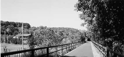
It's always a treat to visit a brand new railroad trail. And a visit to the one that just opened west of Hancock, Maryland, is just such a treat. I was joined by fellow biker Gilbert Elmond on September 7 for a nine-mile (I counted ten) assault on the newly-opened extension of the Western Maryland Rail Trail that utilizes the former roadbed of the Western Maryland Railway between Hancock and Pollypon. It is paved with a super-smooth asphalt surface ideal for biking or roller blading.
The portion of the trail we were biking is the second of three sections. The first section 11 miles, between Big Pool Junction and Hancock was opened in 1998. (I've been on that portion several times.) A third section extending another two and one-half miles from Pollypon to Pearre is slated to open next year.
It was a superb late summer day as we began our adventure from Hancock. It was early in the afternoon, and there were a number of folks on the trail, many walking or roller blading. But once we had proceeded beyond about a mile from Hancock, the number of folks dwindled to the point that we almost had the trail to ourselves.
It was here, too, that memories abounded...
My very first visit to this portion of what is now a trail was in 1963 on a train. In fact, it was my first-ever fantrip! The train was called the Blue Mountain Express, a fall-foliage offering by the Baltimore Chapter of the NRHS from Baltimore to Cumberland. It was great excitement for me to be riding in a passenger train, compete with dining cars (supplied by the B&O), on a freight-only railroad. I learned, too, that there really was such a thing as a railfan (until then I had considered myself to be an anomaly Ha!). And before the train even got back to Baltimore, I submitted by application for NRHS membership. (I have been a member ever since.)
A year or two later I actually got a cab ride over the line (but that's a different story)!
Then, in the fall of 1988, I was there to see the track getting ripped up. In fact, the rail was actually being lifted by a train the last train to run on the line which pulled a string of rail cars followed by a winch and a "sled" that yanked the rail from the ties as the train inched its way forward. It was very depressing.
The once proud Western Maryland Railway had its through route to Cumberland abandoned by the Chessie System in 1975. The folks at Chessie simply concluded that the parallel B&O line could handle all of the traffic, which it has. The WM line west from Hagerstown was retained as a through route as far as Big Pool Junction where traffic accessed the B&O line via a bridge to Cherry Run, West Virginia, and remains in service today. The WM's former main line west from Big Pool Junction was retained as a stub-end branch line for about 20 miles to Tonoloway, but only the 10-mile portion as far as Hancock saw any revenue business. It is understood that the portion from Hancock to Tonoloway was retained with the expectation that traffic might soon develop to move sand from a large deposit in the area, but this never happened. For a while, the portion between Hancock and Tonoloway was used for the storage of cars; then, in 1984 and 1985, it was used to instruct management personnel in train-handling procedures making use of locomotives and a train of loaded ballast cars. (I was there to see that operation, too.)
This, then, represents the "memories" I had of the railroad that is now the bike trail we were riding that day. It was great to know, too, that the resource originally created as a graded railroad is now once again being made available for such a useful purpose.
The section of the trail we were riding was opened to the public on June 10 of this year. By comparison, it is far more peaceful than the first (Big Pool Junction to Hancock) section, which directly parallels Interstate 70 over most of its length. That section is extremely noisy because of the trucks and other traffic. West of Hancock, the area is much more serene.
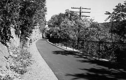
Moving west, the terrain is typically characterized by the Potomac River on the left (with the C&O Canal and towpath sandwiched between the river and the rail trail), and cliffs, hills or farmlands on the right. The rail trail climbs somewhat higher than the adjacent towpath, affording a good view of the river (trees permitting).
The asphalt surface is so smooth that there is a tendency to bike at a fast pace, but our need to stop often to take photos and revel in the surroundings kept us to a leisurely pace.
Then, abruptly, the trail stopped! No "terminus" as one might expect just a gate and a sign saying that the trail had ended. Just beyond this point is a bridge the only major bridge we had seen on the section we were on that trains had formerly used to span a channel to a pool on the north side of the right of way. South of the bridge are the remains of a canal lock. According to information provided by Maryland's Department of Natural Resources, the pool was a small body of water where canal boats would sequester for the winter freeze. It was called Pollypon.
Gilbert and I took some time to explore. We walked down to the towpath (not an easy task at that location), and walked east to the remains of Feeder Dam No. 6. The dam was breached a number of years ago, but at one time it supplied the C&O Canal with water. We had been to this location once before on a towpath biking adventure. We even considered biking back to Hancock on the towpath this time rather than the rail trail, but we opted (for this occasion, at least) to stay on the rail trail.
When the state announced in 1994 that it had purchased the right of way from CSX for use as a trail, I wondered if its proximity to the towpath (averaging only a few hundred yards) would tend to present too much duplication for recreational purposes. In short, would the towpath and rail trail simply compete with each other with a resultant siphoning of users from each? The answer may lie in the surface base they have asphalt for the rail trail, and stone, clay and dirt for the towpath. By its historic import, the towpath must remain accurate to its dirt-base heritage. Much of it currently exists today as a pair of ruts with a grass mound in the middle, rather bumpy in places. (It is fun to bike upon, though.) The rail trail is easier for biking and the only route available for roller blading, the towpath is easier for horses (which are not even permitted on the rail trail), and hikers can enjoy both about equally. Then there is the accessibility issue for the physically challenged. (The towpath is not particularly wheelchair-friendly; the rail trail is ideal). Moreover, the rail line was a ready corridor; had it not been acquired when it was, regardless of its location, it might not have been available later. Hopefully, future projects will provide for easier access between the two trails than what is available now at many secluded spots.
To get on the Western Maryland Rail Trail, you may park in the lot specified for the trail at Big Pool Junction (take exit 12 from I-70), and parking for both sections is available at Hancock.