This article was published in the January 2000 issue of the Bull Sheet...
B&LE Meadville Branch Survey
By Thomas K. Kraemer
BACKGROUND . . .
The Bessemer and Lake Erie Railroad has always been known for its "high iron" main line and operations. However, during its history, three branch lines were operated stemming from its main: The Hilliards, the Meadville and the Western Allegheny Railroad (the WA officially becoming part of the Bessemer in 1967).
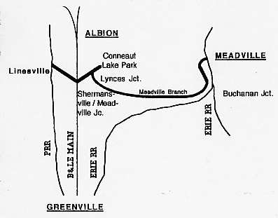
The line that would eventually become the 15.6 mile "Meadville branch" was completed in 1881 as part of the original "Meadville RR" (reorganized several times to finally be known as the Meadville, Conneaut Lake and Linesville RR) to connect the Atlantic and Great Western (Erie) at Meadville with the PRR-controlled Erie and Pittsburgh RR at Linesville - an "East/West" route, 19.1 miles.
As the "Bessemer" (Pittsburgh, Shenango and Lake Erie RR at the time) constructed its main line northward from Greenville toward Albion in 1891, it crossed the MCL&L near Shermansville at a location about 21 miles south of Albion, PA, and about 19 miles north of Greenville. The Bessemer shortly thereafter leased the line from the MCL&L and operated it as a branch, with it officially becoming merged into the Bessemer system in 1949.
The Bessemer's purpose of the branch obviously was to reach business and industry in Meadville, but it also saw passenger service to what's known today as "Conneaut Lake Park" - known as "Exposition Park" until 1920. The park was developed in conjunction with railroad interest and funding in hopes for generated passenger traffic, and as a pleasant meeting place for associated corporations and stockholders (private organizations were also welcome). To be able to provide direct access to the park, the railroad constructed a one-mile spur from a place on the branch called Lynces Junction to the park itself.
The automobile would eventually put an end to the need for passenger trains running to the park, and the service was discontinued in 1934 (the spur finally being abandoned in 1969). The portion between Linesville and Shermansville (Meadville Jct.) was abandoned in 1953, and the portion between Meadville Junction and the crossing of Route 322 (just outside Meadville) was abandoned in 1977.
Actually, a small section of the original line is still active in Meadville, operated by NS (Conrail), as an industrial spur off the former Erie main. It serves local industry and is referred to, in NS's timetable, as the "Mead Industrial Track." Today, Meadville Junction on the B&LE is still an active location with a 10,000 foot CTC passing siding and a couple of non-controlled sidings between the "mains" used for setting out bad orders or placement of MOW equipment and rolling stock...but a cinder "wye" grade on the east side of the main line is all that remains of the branch that named the location.
WHAT ELSE IS LEFT? . . .
While living temporarily in the Conneaut Lake area last winter, I had several opportunities to explore what was left of the old Meadville branch. Unfortunately, the section between Shermansville and the now-removed PRR at Linesville is practically untraceable, with almost 50 years worth of nature's reclamation of the land.
The section of right-of-way between Meadville Junction and Conneaut Lake (including the spur from Lynces Junction) appears to be fairly intact, however many gates and posted signs prevent the casual "industrial archeaologist" from gaining access to most areas. But wait... that still leaves a good 12 miles' worth of right-of-way to explore... between Conneaut Lake and Meadville.
CONNEAUT LAKE TO MEADVILLE HIKE . . .
With the right-of-way becoming fairly remote and less accessible beyond Conneaut Lake, I decided to hike the section between the south end of Conneaut Lake and where the trackage starts up again outside Meadville - about 12.5 miles. So on a clear day last August, I teamed up with my friend (and fellow railroader) Jay Schmucker to explore and document what was left of that section of the route.
After crossing Route 6 in Conneaut Lake, the right-of-way is being used as a driveway to a privately-owned (and open to the public) winery. As we walked on by the winery building after traversing its driveway, some folks sitting on the porch of the establishment looked at us suspiciously (it's a 90's thing), but offered no resistance. It is possible that the property had been purchased from the railroad and was indeed theirs, but no signs were posted threatening passage. Behind their building (and beyond a nicely mowed backyard), the line picked back up as a fairly clear trail through what we could tell were Pennsylvania State Game Lands. About a mile beyond the trailhead, we came across an official Pennsylvania-type sign stating, although faded and somewhat unclear, that the right-of-way (and its access to the land) was restricted - to be used only during the months between July and December. Since it was August, we were OK, and continued on. The trail was fairly well used as a footpath and was clear, offering views of unspoiled swamp land and smooth rolling hillsides complimented by shady wooded passages. A few overgrown tree limbs blocked the way slightly, but the trail was easily passable.
Since most of the railroad was built on the towpath of the old Meadville Branch of the Erie Extension Canal, I found its characteristics to be similar to that of the C&O canal towpath in the East - long sweeping curves with a raised grade, and, obviously, a canal bed about 20 feet wide in parallel with the right-of-way. The canal had become overgrown, of course, but still held water in places and was filled with various water plants and wildlife. An old farm bridge (in poor condition) across the canal at one point was the only evidence we had found thus far concerning the actual railroad...several lengths of the old rail and ties were used in its construction. The small wooden trestle over Mud Run had been removed, with a few pilings still standing in the stream bed.
From the crossing of Brown Hill Road to West Vernon Road (about two miles) the trail continued to be clear and usable - the landscape becoming more of a densely wooded area. The trail seemed very remote, but at one point we were overtaken by a kid driving an ATV at an aggressive pace (disruptive, yet probably to thank for keeping the trail open!).
East of West Vernon Road, a local farmer had stored hay rolls squarely on the right of way, with the area behind the rolls having become totally grown in and offering difficult passage. We also seemed to lose sight of the old canal at that point. The Watson Run bridge (or the lack thereof) presented our next obstacle. The bridge appeared to have been about 40 feet in length and wooden during its day. Luckily, the water level in Watson Run was low, and we were able to descend the bank and cross the stream bed without the bridge after all. Dense vegetation on either side of the bridge (and its cement abutments) proved to slow our passage until we could find a clear trail once again.
East of Watson run road, the trail finally did clear up - providing use initially as a driveway, then an ATV trail for about another half mile. The ATV trail would dart off to a neighboring farmer's field as the right-of-way entered a shallow cut through a wooded ridge for approximately one mile. Passage through the cut was impossible, as trees from the woods on either side had fallen into the cut. Drainage through the cut was poor, and dense vegetation filled any open spaces between the fallen trees. We were forced to ascend the cut and hike through the woods until we came across Route 19.
Since the right-of-way had been lost for the time being, we decided to follow country roads for a mile or two until we were east of Interstate 79, where we found the trail once again. The trail was perfectly clear as we picked it up heading east from Mt. Pleasant Road, just under the I-79 bridge. A sign restricting the use of motorized vehicles was all we saw entering the trail, along with metal posts spaced to limit anything wider than a horse's behind. The trail looked to be well used - but maintained only by its use.
At the crossing of the Mercer Pike, a parking area (again poorly maintained) and some vandalized signs proclaimed the right-of-way as a public bike trail - a good intention, but the route was not paved making it suited best for mountain bikes or hiking. The trail curved gently northward toward Meadville at that point, and NS's (former Erie) Meadville Line could be seen paralleling between the trees of a thinly wooded area.
At the railroad location known as "French Creek," the line curves sharply northward and actually shares the right-of-way with NS's (original Erie RR) Meadville Line for a few hundred feet. Apparently, there was an interchange there at one time. A few concrete "stumps" from mechanical interlocking devices could be found in the immediate area, but we could find no evidence of a tower. We assumed the junction was controlled by Erie's nearby "BK" tower at Buchannan Junction where the branch to Franklin splits from the old Erie main (tower closed and razed about 1986).
The B&LE continued to curve sharply northward, with the "Erie" curving less sharply and crossing French Creek on a girder bridge. At that point, the B&LE trail entered its most scenic section, with a steep wooded hillside to the left and French Creek on the right. As we walked, we did actually meet some other hikers and an older couple on mountain bikes who seemed to be enjoying the trail.
As the valley spread out, farmland was developed in what was the floodplain of French Creek. A couple of bridges had been constructed over small runs intentionally built for the trail and looked to be fairly new (they were not configured from original railroad structures).
As we neared our destination of Meadville, the line curved gently and came quite close to I-79 - the scenery continued to be nice, but noise from the highway subtracted from the remote atmosphere the trail had presented thus far. But that was only for a short distance, and as I-79 curved toward the west slightly, our trail curved slightly east, then straightened out for the last mile into civilization.
The trail ends, unmarked, at a spot on Route 6 just outside the city of Meadville - near Value City plaza, Hoss's Steak House, Pizza Hut, etc...the colorful array welcomed us back to the "real world" once again. Our trip on the Meadville branch was second only to being in a caboose pulled by an orange-and-black SD-7.
.